Planning your Flight
Oceanic flight planning can be a handful. With so many nuances and procedures that are different from domestic flight, it is easy to feel overwhelmed. However, with enough practice, it is an immensely gratifying skill and a tool that you can add to your VATSIM arsenal.
In this article, we will outline the basics of oceanic flight planning and some tips and tricks you can take advantage of to perform a successful oceanic flight.
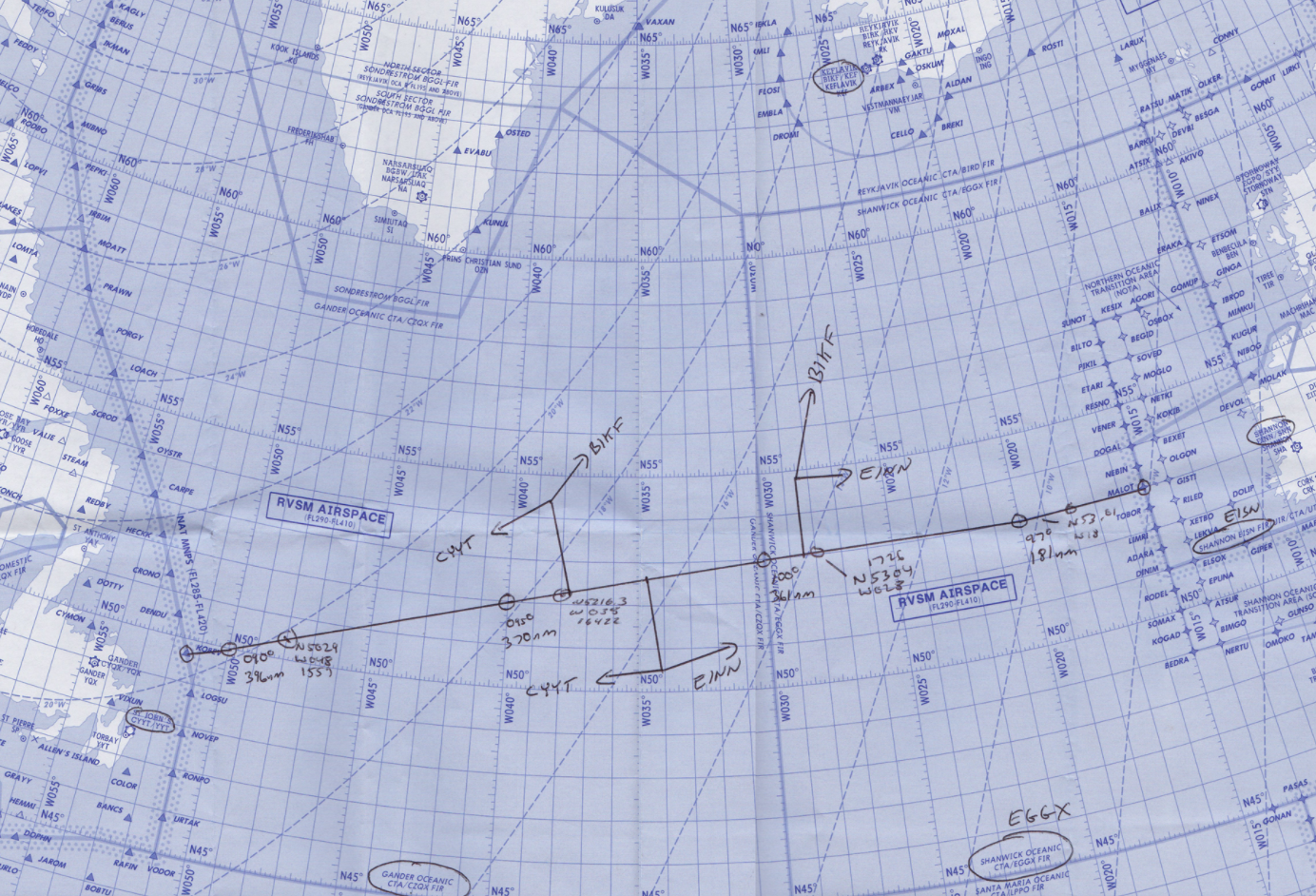
Routes
In the previous article (see NAT Tracks) we discussed the two main types of oceanic routing, NAT Track and Random Routing. However, which one do you choose?
As discussed, eastbound and westbound flight on the OTS are only available at certain times of the day. Much of the time, it will be possible to utilise a NAT track, and if this is the case, then it should be the preferred option, however, there are many situations where a published track is simply not available for a pilot's direction of flight and/or requirements. Therefore, a Random Routing is required. Many flight planning tools such as SimBrief generate a suitable Random Routing, however, at times, it may be necessary to make one up. In that case, observe the high-level weather forecast and plot a logical route, for example, select a waypoint every 10 degrees of longitude.
Flight Levels
Each of the NAT tracks has a published set of specific flight levels allocated between the FL310 and FL400 band. This makes altitude choice relatively easy for a designated track.
Random Routings, however, have their own set of flight levels depending on direction of flight. These are summarised in the below table:
| Level | Time | Direction |
| FL430 | All | Westbound |
| FL410 | All | Eastbound |
| FL400 | All | Westbound |
| FL390 | All | Eastbound |
| FL380 | 0801z-2229z 2230z-0800z |
Westbound Eastbound |
| FL370 | All | Eastbound |
| FL360 | All | Westbound |
| FL350 | All | Eastbound |
| FL340 | 0801z-2229z 2230z-0800z |
Westbound Eastbound |
| FL330 | 1901z-0959z 1000z-1900z |
Eastbound Westbound |
| FL320 | All | Westbound |
| FL310 | All | Westbound |
| FL300 | All | Westbound |
| FL290 | All | Eastbound |
Mach Number
Instead of Indicated Airspeed (IAS), Mach is used in oceanic airspace. Mach is very important for aircraft operating at high levels at high speed, as it is a better representation of the aircraft's actual speed through the air than ground speed or IAS at cruising levels. Pilots may file their preferred Mach number and in most cases will receive a clearance with that Mach number. It is rare for a controller to assign anything more than .02 Mach below or .01 Mach above the requested speed.
Other General Tips
- If you don't understand what the controller said, say so! They will explain it to you in a different way. Likewise, if you cannot do something, tell them that you are ‘unable’ and they can find an alternative.
- If you are not sure about any aspect of your oceanic flight, don't be afraid to private message the oceanic controller. More often than not, they will be more than happy to help you out.
- If you need something from the controller, for example, a change of flight level or a change of speed, just ask! In many cases, the controller can accommodate the request.
- For information regarding appropriate phraseology, please view our phraseology guides for clearances, position reports and amendments.
Sources
NAT Document 007